
By Emily Rinaman, Technical Services Manager
Someone looking at an old map of Tiffin may become more lost after looking at it than before. And Tiffin is by far the only city that has been transformed over the course of hundreds of years. At first glance, the map may look familiar, but upon closer inspection, someone familiar with Tiffin will see that in some cases, street names have changed, buildings have moved or are gone completely, and of course, it’s grown in size.
While maps have evolved from handwritten drawings to technological systems that show you where you are in real-time, maps help provide the person using them with a sense of ease. Maps are intended to keep someone from getting lost.
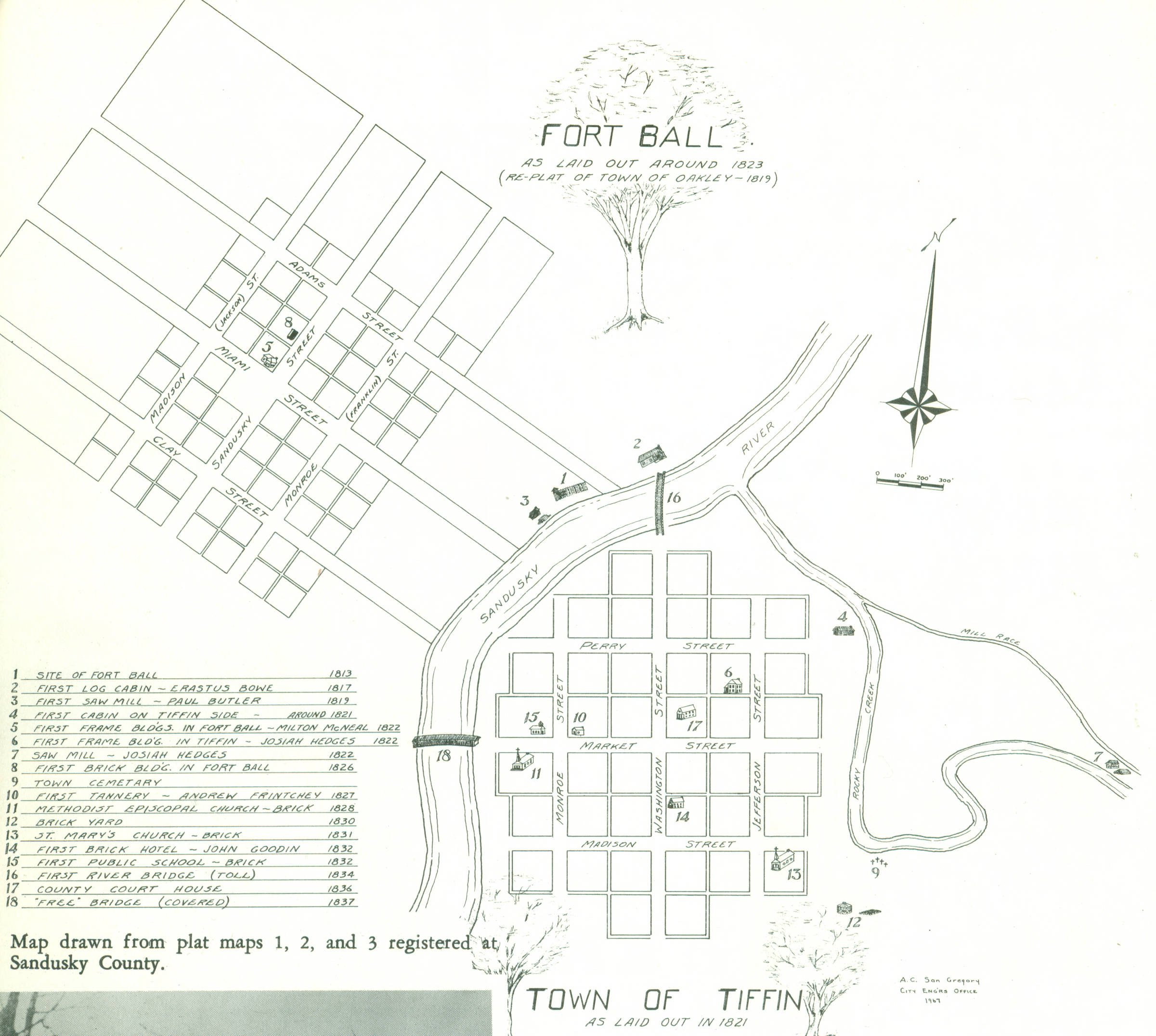
A map of the original Tiffin, which was separated as Fort Ball to the northwest and Tiffin to the south of the Sandusky River.
Each year, Tiffin-Seneca Public Library hosts a Community Read, featuring a fiction piece in the spring and a non-fiction work in the fall. This year’s Community Read has focused on the book, The Lost Apothecary by Sarah Penner. The title is pretty straightforward; the present-day main character uses maps of London to unearth an 18th-century apothecary that had long been forgotten, lost to time. She had to decipher these maps from how London appeared then to how it had morphed.
What one who doesn’t call Tiffin his or her hometown might not realize, is that Tiffin was once two separate towns, Tiffin on the south side of the Sandusky River, and Fort Ball on the northwest side of the river (see photo). Eventually, after much arguing and resulting resentments, Tiffin won out. Similarly, Fostoria was once known as Risdon’s Square.
It was common for villages of varying sizes, even cities, to be named after places of origin of the early settlers or nearby geographical landmarks. New Riegel was named in honor of Riegel, Germany where many immigrants had traveled from and Green Springs was named for the natural springs nearby (For a full list, Destination Seneca County gives a brief description of each town on their website; the link is listed in the “resources” section of this article).
Other towns and cities are named after notable individuals. While Tiffin was named after the first governor of Ohio, many Seneca County towns were named after major benefactors who built them up. Fostoria is named in honor of Charles Foster, McCutchenville after Joseph McCutchen, and so on. (One wonders what Mr. McCutchen would have thought of the nickname, “Scutch”?)
There are neighborhoods in both Tiffin and all of the surrounding towns, despite their size, which have “additions” listed on older maps, named after an individual who likely sold their land to the growing municipality. Many streets in these new neighborhoods are the lasting namesake of those long-gone individuals. Tiffin, for example, has Tomb’s Addition and Wentz Addition towards the northern edges of the city limits. In Fostoria, there was a Crocker’s Addition and Bettsville had a Bett’s Addition from the founder himself.

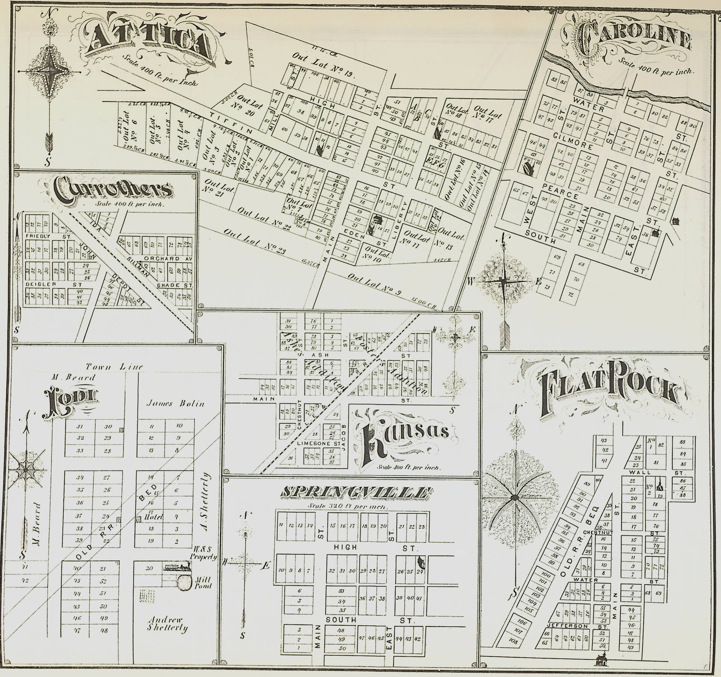
Maps of Attica, Caroline, Carrothers, Flat Rock, Lodi, Kansas and Springville were all shown on one page in the 1874 Seneca County Combination Atlas Map.
The “avenues” section of north Tiffin was possibly named in order of their accessions into the city. On a map in the Combination Atlas Map of Seneca County, they are noted as “First Highland Addition,” “Second Highland Addition,” “Third Highland Addition,” etc. These types of maps are known as plat maps.
Plat maps were a type of map approved by the Public Land Survey System and were particularly common in the Midwest because the land could easily be divided into even sections with relatively flat topography. They were often gathered into atlases, organized by townships. The Ohio History Connection has an entire collection called the Ohio Canal Plat Map Collection and atlases for almost every county in Ohio.
Speaking of the canal, the Third Annual Heritage Festival booklet shows an early proposed route for the Erie Canal, one that was eventually discarded as a huge disappointment to the locals. This particular proposed route would have gone through West Lodi, Republic, and Carey from Sandusky.
This map shows the location of “Abbott’s Island,” where several members of the Klingshirn family and debris from the 1913 flood became lodged after traveling several miles. According to this map, Albert Abbott owned the land to the west of the “island” at the time of the flood.
Further back in time, you’ll also find maps showing areas in Seneca County where Native Americans inhabited. The Big Spring Indian Reservation was located in the southwestern corner of Seneca County, where Wyandots resided in the early 1800s. Near Fort Seneca, prehistoric peoples hunted and camped in cliffs and on the edge of the river (a previous blog article from November 2021 explores this in further detail). It was also claimed that of the 8,233 prehistoric earthworks throughout Ohio, only three of them are attributed to Seneca County.
The Cincinnati Public Library’s section on Ohio Memory has maps of each county in Ohio with their respective Native American trails, village, burial sites/cemeteries, and “enclosures.” These maps indicate 23 recorded sites scattered throughout Seneca county (as of 1914), including two located slightly northwest of Bloomville, one in Eden Township along Rock Creek, several in Thompson Township, and others between Flat Rock and Reedtown, south of Melmore, east of Bascom, north of Berwick, along Beaver Creek in Adams Township north of Lowell, and in Pleasant Township south of Fort Seneca.
Maps were also presented differently than they are now. Modern society is used to measuring distance in feet, yards, and miles. However, maps of Seneca County often used measurements called furlongs and rods, which were old English units of measurement based on ancient farming practices. A history buff or a horse-racing fan may know these conversions already, but it would be hard to find a device or phone app that lets you convert our modern measurements into a rod or a furlong.
A rod is simply 16 ½ feet and an acre is 160 square rods, but the furlong takes on a much more complicated system. A livestock-led plow usually averaged so many furrows per day. A “furrow-long” was combined to create a “furlong,” or 660 feet. One mile equals eight furlongs. An Ohio auctioneer has a pretty Midwestern explanation: “Perhaps the easiest way for us Americans to envision it is as a rectangle the size of an American football field minus the two endzones. The acre was a down-to-earth estimate of the area that could be plowed in one day with a yoke of oxen. The furlong is 10 chains long and the width of an acre just happens to be one chain.”
Works cited:
Baughman, A.J. “Seneca County History Volume 1”. Seneca County Digital Library. https://ohiomemory.org/digital/collection/p15005coll27/id/17053
Lang, William. “History of Seneca County from the Close of the Revolutionary War to July 1880.” Seneca County Digital Library. https://ohiomemory.org/digital/collection/p15005coll27/id/17561
Lunn, Charlie. “The History of Plat Books: Their Past, Present and Future.” Rockford Map. March 6, 2018. https://rockfordmap.com/blog/2018/03/06/the-history-of-plat-books-their-past-present-and-future/
Mills, William C. “Archeological atlas of Ohio : showing the distribution of the various classes of prehistoric remains in the state, with a map of the principal Indian trails and towns.” Ohio State Archaeological and Historical Society. https://digital.cincinnatilibrary.org/digital/collection/p16998coll9/id/2058
Rerick Brothers. “The County of Seneca, Ohio: An Imperial Atlas and Art Folio, including Chronological Chart, Statistical Tables, and Description of Surveys.” 1896. https://www.ohiohistory.org/wp-content/uploads/2022/01/Rerick_Brothers-_Atlas_and_Art_Folio_of_Seneca_County_1896.pdf
Sayger Printing. “Third Annual Heritage Festival 1817-1891.” https://ohiomemory.org/digital/collection/p15005coll27/id/27465
Stewart, D.J. “Seneca County History Combination Atlas Map 1874.” Seneca County Digital Library. https://ohiomemory.org/digital/collection/p15005coll27/id/4517
Strischeck, Dev. “Acres, Furlongs, Chains and Rods? That’s About the Size of It.” January 17, 2020. https://www.linkedin.com/pulse/acres-furlongs-chains-rods-thats-size-dev-strischek
Seneca County Genealogical Society. “Original Land Entries of Seneca County, Ohio.” Seneca County Digital Library. https://ohiomemory.org/digital/collection/p15005coll27/id/44828
“Villages.” Destination Seneca County. https://www.destinationsenecacounty.org/things-to-do/by-type/historical/villages (accessed Feb. 22, 2022).